The Ordnance Survey (Third Edition) Map 1916
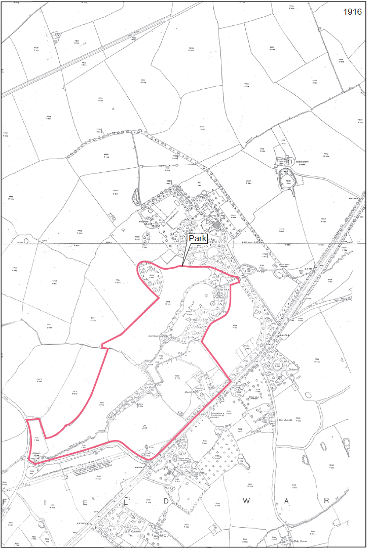
OS 1916Although the map was surveyed in 1913 - 1914. The map’s publication was delayed until 1921, probably due to the need to prioritise mapping for the War Department during the Great War. It is referred to as the 1916 or 1921 map. 

Little change is mapped since 1904, with the exception of the Elan Aqueduct, which crosses the extreme south-eastern corner of the park. The adjoining L-shaped building (White Hill Farm) continues to be mapped. The new canalised route of the Griffin’s Brook has now been joined-up to the historic route of the brook, which also continues to be mapped. A rectangular Bath, with walls on three sides forming a U-shape in the plan is mapped adjoining the historic stream course. The pattern of field boundaries surrounding the park is very similar to that mapped over 80 years earlier (1840 Tithe Map).

By 1916 the north-eastern group of farm outbuildings had been considerably enlarged to the rear. The other buildings within this complex were probably unchanged. To the north of the Manor House, a narrow belt of trees has been laid out to provide a visual screen to the north of the Manor House and to the south of Middle Park Farm, possibly in anticipation of the development of the farmland to the north, which was to begin in the 1920s. There has been little if any development in the vicinity of the park since 1904.

Return to Maps and Plans


'Reproduced with the permission of the National Library of Scotland'

The Ordnance Survey (First Edition) Six-Inch Map 1884

Extract of 1884 MapThe 1884 OS map (6 inches to the mile) shows a large oval pool or fishpond in the park, which survives to the present. A Boat House is mapped at the southwestern corner of the pool. Despite the layout of the lake, the route of Griffin’s Brook appears unchanged from 1840. Old Park Farm (formerly Park Gate Farm) is mapped at the extreme southern end of the park. 

White Hill Farm, at the junction of modern Bristol Road South and Whitehill Lane, is illustrated in field 819. Within the park, the arrangement of field boundaries is mostly the same as that mapped in 1840. An exception is a field to the east of the fishpond, which is shown on the 1884 map as divided by a line of trees, presumably following a field boundary. The southern of the two fishponds mapped in 1840 is now disused, although the northern fishpond continues to be mapped. 

To the south-east of Bristol Road South, a number of large houses are mapped, including ‘The David’s’, ‘The Woodlands’ and ‘The Priory’. A number of clay pits are also illustrated. Despite these new buildings the landscape surrounding the park remains rural in character. This map was surveyed in 1882 and published two years later. 

Return to Maps and Plans

Return to Heritage Trail, Lake

Link to Full map

'Reproduced with the permission of the National Library of Scotland'

Park Plan 2015The plan shows the park in detail and large versions are displayed on the five community notice boards within the park. There is a much larger, bespoke notice board at the main entrance off Bristol Road South which details brief information panels about the park. 

Leaving the park via the Manor Drive entrance which is alongside the North Copse, the Walking/Cycle Path is well sign-posted and takes one past the Yachting Pool, through Bournville Park and on to Bournville Green, where one can visit Cadbury World, carry on to Bournville Station or join the Rea Valley Cycleway by walking down Mary Vale Road to Stirchley. 

Following the Walking/Cycle Path south leads through the small and peaceful Meadow Brook Park then to Ley Hill Park and the footpath that skirts Frankley Waterworks and ends at Frankley Beeches.

Crossing the Bristol Road, a footpath to the south of the Royal Orthopaedic Hospital leads to Northfield Common and St Laurence Church, the start of the Northfield Revealed Trail.

Return to Maps and Plans

Return to Heritage Trail   

Back to top of page